|
三维地图,是为了更好的数据可视化,以便更好地进行数据分析。ThingJS结合Web地图API开发了更多3D功能,让数据展示更加出色!
CMap 是基于 ThingJS 实现的地图组件库,我们与高德地图导航服务合作开发导航功能,用到其中的路径规划服务,这里的web服务API对所有用户开放,可以轻松开发。 
按照高德的路径规划结果,使用GCJ02坐标系的谷歌影像,导航支持驾车、骑行与步行等交通方式,当然您可以自行开发更多的出行方式,记得使用API前先获取key: https://lbs.amap.com/api/webservice/guide/api/direction 
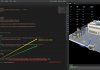
高德地图路径规划服务API是一套以HTTP形式提供的步行、公交、驾车查询及行驶距离计算接口,返回JSON 或 XML格式的查询数据,用于实现路径规划功能的开发。适用场景包括线路查询,以线路结果页面形式展现换乘方案。根据返回线路数据,自行开发线路导航。 开发示例提供起点、终点的按钮设置,根据不同交通方式来设定线路。点击起点按钮,则在地图上单击某处作为起点,终点按钮也是如此。如上图所示。 ThingJS与高德路径导航的开发示例如下: - var app = new THING.App();
- // 设置app背景为黑色
- app.background = [0, 0, 0];
- // 高德地图key 免费版本有次数限制,此处仅供demo使用,如有需要请自行到高德地图网站申请商业版key
- var amapKey = '5791cdaf02f4d44fd979a9f89739d06c';
- THING.Utils.dynamicLoad(['https://www.thingjs.com/uearth/uearth.min.js'],
- function () {
- var startCoord, endCoord;
- var map = app.create({
- type: 'Map',
- attribution: 'Google'
- });
- var tileLayer1 = app.create({
- type: 'TileLayer',
- id: 'tileLayer1',
- url: 'https://mt{0,1,2,3}.google.cn/vt/lyrs=s&hl=zh-CN&gl=cn&x={x}&y={y}&z={z}'
- });
- map.addLayer(tileLayer1);
- // 创建一个图层展示起点终点的图标以及导航结果
- var thingLayer = app.create({
- type: 'ThingLayer',
- name: 'thingLayer'
- });
- map.addLayer(thingLayer);
- // 飞到地球上某一个位置
- app.camera.earthFlyTo({
- lonlat: [116.4365, 39.97479],
- height: 6000,
- complete: function () {
- createUI();
- }
- });
- // 是否点击选择起点按钮
- var selectStart = false;
- // 是否点击选择终点按钮
- var selectEnd = false;
- // 导航方式选择的UI
- var radio;
- /**
- * @param orgin 起点坐标
- * @param destination 终点坐标
- * @param transport 交通方式
- */
- function nav(origin, destination, transport) {
- // 先清除导航结果
- thingLayer.query('.GeoLine').destroy();
- // 构建查询url 不同出行方式构建url的方式不同 具体请参考高德路径规划api
- var navUrl = '?origin=' + origin + '&destination=' + destination + '&key=' + amapKey;
- var drivingUrl = 'https://restapi.amap.com/v3/direction/driving';
- var bicyclingUrl = 'https://restapi.amap.com/v4/direction/bicycling';
- var walkingUrl = 'https://restapi.amap.com/v3/direction/walking';
- if (transport === '驾车') {
- navUrl = drivingUrl + navUrl;
- }
- else if (transport === '骑行') {
- navUrl = bicyclingUrl + navUrl;
- }
- else if (transport === '步行') {
- navUrl = walkingUrl + navUrl;
- }
- // 请求高德地图导航服务
- $.ajax({
- type: 'GET',
- url: navUrl,
- dataType: 'json',
- success: function (data) {
- // 先判断是否成功
- if (data.status === '1' || data.errcode === 0) {
- var path;
- // 不同交通方式返回接口结构不同,具体请参考高德路径规划api
- if (transport !== '骑行') {
- path = data.route.paths[0];
- }
- else {
- path = data.data.paths[0];
- }
- var distance = path.distance;
- var duration = path.duration;
- var steps = path.steps;
- var coordinates = [];
- for (var i = 0; i < steps.length; i++) {
- var polyline = steps[i].polyline;
- var coords = polyline.split(';');
- for (var j = 0; j < coords.length; j++) {
- var coord = coords[j].split(',');
- coordinates.push([parseFloat(coord[0]), parseFloat(coord[1])]);
- }
- }
- // 将路径规划结果创建一个GeoLine对象,并添加到图层
- var road = app.create({
- type: 'GeoLine',
- name: 'road' + i,
- coordinates: coordinates,
- renderer: {
- type: 'image',
- lineType: 'Plane',
- color: [255, 0, 0],
- imageUrl: 'https://www.thingjs.com/uearth/uGeo/path.png',
- // numPass: 6,
- width: 6,
- effect: true,
- speed: 0.1
- }
- });
- thingLayer.add(road);
- // 飞到GeoLine对象
- app.camera.earthFlyTo({
- object: road
- });
- }
- }
- });
- }
- // 给地图添加点击事件,点击地图时选择起点或终点,并在地图上添加一个GeoPoint
- map.on('click', function (e) {
- if (selectStart) {
- startCoord = e.coordinates.toString();
- selectStart = false;
- document.body.style.cursor = 'default';
- var geoPoint = app.create({
- type: 'GeoPoint',
- name: 'startPoint',
- coordinates: e.coordinates,
- renderer: {
- type: 'image',
- url: 'https://www.thingjs.com/uearth/uGeo/start.png',
- size: 3
- }
- });
- thingLayer.add(geoPoint);
- }
- if (selectEnd) {
- endCoord = e.coordinates.toString();
- selectEnd = false;
- document.body.style.cursor = 'default';
- var geoPoint = app.create({
- type: 'GeoPoint',
- name: 'endPoint',
- coordinates: e.coordinates,
- renderer: {
- type: 'image',
- url: 'https://www.thingjs.com/uearth/uGeo/end.png',
- size: 3
- }
- });
- thingLayer.add(geoPoint);
- if (startCoord !== undefined && endCoord !== undefined) {
- // 获取当前radio选中的值
- var transport = radio.getValue();
- nav(startCoord, endCoord, transport);
- }
- }
- });
- // 创建UI界面
- function createUI() {
- // 创建选择起点按钮
- new THING.widget.Button('选择起点', function () {
- selectStart = true;
- document.body.style.cursor = 'pointer';
- thingLayer.query('.GeoPoint').destroy();
- thingLayer.query('.GeoLine').destroy();
- });
- // 创建选择终点按钮
- new THING.widget.Button('选择终点', function () {
- if (selectStart) {
- return;
- }
- selectEnd = true;
- document.body.style.cursor = 'pointer';
- });
- // 创建一个配置界面组件
- var panel = new THING.widget.Panel({
- titleText: '交通方式',
- hasTitle: true,
- width: 150
- });
- panel.positionOrigin = 'TR';// top-right
- panel.position = ['100%', 0];
- // 添加 单选框 组件
- radio = panel.addRadio({ 'radio': '驾车' }, 'radio', ['驾车', '骑行', '步行']);
- // 监听单选框选项改变的事件
- radio.on('change', function (ev) {
- nav(startCoord, endCoord, ev)
- })
- }
- });
ThingJS让3D应用的开发与集成更为快捷灵活。
|